


The project aims to bring zoning data from around the country into one database, making it easier for planners and researchers to compare policies and their impacts.
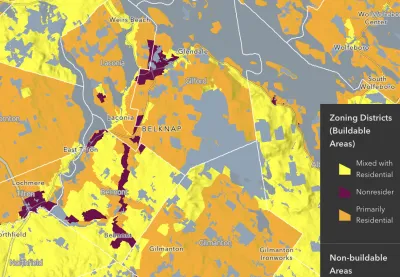
An article in PD&R Edge highlights progress on the National Zoning Atlas, an effort to consolidate nationwide zoning data into one GIS database to let researchers analyze and compare zoning policies and their effects. “The purpose of the atlas is to offer insight into zoning’s effects and democratize land use decisionmaking through comprehensive, digitized, and user-friendly zoning information.”
The creators of the Zoning Atlas say “the decentralization of zoning laws has hindered the identification of problems arising from land use regulations.” The effort is already underway in 21 states, and almost complete in New Hampshire.
“An ongoing challenge that the atlas can help address is the obfuscating effects of complex and competing land use interests to reform.” As the article explains, “Aggregating this information makes the scale of statewide challenges more readily apparent and could bring stakeholders on board to address the collective action problems that intricate zoning systems pose.”
FULL STORY: Creating the National Zoning Atlas


National Zoning Atlas Expands
The online tool can help city and state officials understand where zoning codes need reform and how they compare to other localities.
How a National Zoning Atlas Can Clarify a Legal Patchwork
A massive effort is underway to compile local zoning regulations and other laws that impact how and where housing is built.

Colorado Bill Would Legalize Housing ‘In God’s Backyard’
Churches and religious institutions around the country are calling for zoning reforms that would allow them to build housing on their underused properties.

Analysis: Cybertruck Fatality Rate Far Exceeds That of Ford Pinto
The Tesla Cybertruck was recalled seven times last year.

National Parks Layoffs Will Cause Communities to Lose Billions
Thousands of essential park workers were laid off this week, just before the busy spring break season.

Retro-silient?: America’s First “Eco-burb,” The Woodlands Turns 50
A master-planned community north of Houston offers lessons on green infrastructure and resilient design, but falls short of its founder’s lofty affordability and walkability goals.

Test News Post 1
This is a summary

Analysis: Cybertruck Fatality Rate Far Exceeds That of Ford Pinto
The Tesla Cybertruck was recalled seven times last year.

Test News Headline 46
Test for the image on the front page.
Urban Design for Planners 1: Software Tools
This six-course series explores essential urban design concepts using open source software and equips planners with the tools they need to participate fully in the urban design process.
Planning for Universal Design
Learn the tools for implementing Universal Design in planning regulations.
EMC Planning Group, Inc.
Planetizen
Planetizen
Mpact (formerly Rail~Volution)
Great Falls Development Authority, Inc.
HUDs Office of Policy Development and Research
NYU Wagner Graduate School of Public Service