


Shared streets, the contemporary vernacular used to describe streets that have been intentionally redesigned to remove exclusive boundaries for pedestrians, bicyclists, cars, etc., work well within a special set of conditions. It is, in reality, just a new way of describing the original use of streets (see this previous post for more on that). The most promising candidates for shared streets are those where traffic volumes are not too heavy, the route is not a critical corridor for vehicular through-traffic, activities and attractions along the street are plentiful, short distance connectivity is viable, and a critical mass of pedestrians (perhaps enough to pack sidewalks at certain times) exists. A shared street may also be suitable in places where there is a desire to induce such conditions; however, care must be taken to understand the larger network effects of shifting or slowing down vehicular traffic. But in some instances, seemingly unrelated changes to traffic patterns or the effects of a coincidental collection of the above conditions sometimes go unnoticed until a street that may have been all about cars gradually shifts into something I refer to as a “de facto shared street”.
Shared streets, the contemporary vernacular used to describe streets that have been intentionally redesigned to remove exclusive boundaries for pedestrians, bicyclists, cars, etc., work well within a special set of conditions. It is, in reality, just a new way of describing the original use of streets (see this previous post for more on that). The most promising candidates for shared streets are those where traffic volumes are not too heavy, the route is not a critical corridor for vehicular through-traffic, activities and attractions along the street are plentiful, short distance connectivity is viable, and a critical mass of pedestrians (perhaps enough to pack sidewalks at certain times) exists. A shared street may also be suitable in places where there is a desire to induce such conditions; however, care must be taken to understand the larger network effects of shifting or slowing down vehicular traffic. But in some instances, seemingly unrelated changes to traffic patterns or the effects of a coincidental collection of the above conditions sometimes go unnoticed until a street that may have been all about cars gradually shifts into something I refer to as a "de facto shared street".
A few weeks ago I referred to the chaos perceived by drivers at Gansevoort Plaza, in Manhattan's Meat Packing District, where pedestrians, bicyclists, cars, taxis, and buses mingle in an informal and unplanned way, as a de facto shared street. This is in contrast to the shared streets that have been more recently implemented by professional planners and engineers as a means of changing the way areas between property lines are perceived by people; that is, from streets designed for cars to public spaces equally accessible by everyone. While the newly redesigned Gansevoort Plaza was specifically crafted to enhance the shared street characteristics of the space while staying within the legal confines of New York City street design, its fundamental design criteria were based on the observed dynamic interaction amongst modes across the swath of historical Belgian block that many believe contributed to the area's growing appeal. In fact, when we began the conceptual design process, we based the original redesign concepts on that activity, with a little sprinkling of the traffic patterns observed in another Manhattan de facto shared street, Union Square West (photo further down the page). The end result is something that, due to being an early proof-of-concept in a city where aggressive change never comes easy, does not meet the letter, but rather the spirit, of shared street design.
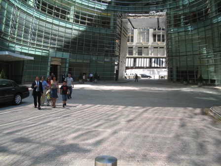
Gansevoort Plaza in Manhattan's Meat Packing District Before Redesign
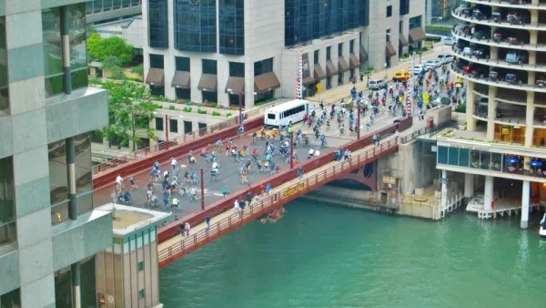
Over years of roaming through Manhattan, it turns out that the Big Apple is home to an interesting smattering of urban places that have, for various reasons, developed independently, to an extent, as de facto shared streets. Photos and short captions of some less obvious examples are provided below. Perhaps the most valuable take-away from this exercise is to demonstrate that the shared street concept is not nearly as foreign to the American psyche as some may say, and that if you look closely enough, you might find examples of de facto shared streets in your city too. Enjoy!
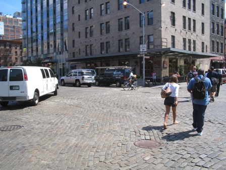
Broad Street in downtown Manhattan enjoys limited traffic due to security restrictions around Wall Street. The result is an area where pedestrians frequently spill out into the street, since sidewalks are narrow and frequently squeezed by scaffolding. Cars roll slowly and mix with pedestrians and bicyclists. The asphalt isn't so appealing, but the prospects are!
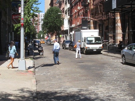
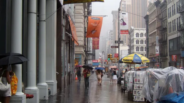
Wooster Street is an example of the de facto shared street feel of many SOHO streets. Low vehicular traffic volumes, big rushes of tourists on foot, and bumpy, Belgian block paving contribute to the effect.
Bloomberg Circle in Midtown is a quasi-public street (didn't research the consents here) where limited signage, minimal traffic, and strong desire lines (to cross the circle rather than walk around it) combine with pavers to create a de facto shared street.
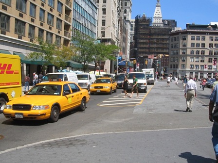
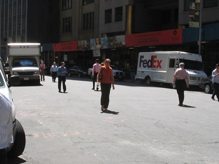
Union Square West is a bit chaotic since striping and spaces are so broad, but pedestrian volumes to and from the park result in an informal mingling of foot and vehicular traffic. There is a lot of opportunity to redesign this area, but even the current de facto shared street conditions were enough to build a friendly analogy and inspire roadway design elements of the new Gansevoort Plaza just a few blocks to the west.

‘Togetherness’ as a Synonym for ‘Transportation’
Transportation is a fundamental aspect of community cohesion, and should be considered a synonym for togetherness.
Opinion: It's Time To Put People Ahead of Cars in SoHo
A proposal from SoHo Broadway Initiative aims to prioritize pedestrian and bike infrastructure and discourage car traffic to make the neighborhood safer and more comfortable for the people who live and work there.
Chicago Dismantles Leland 'Slow Street' Three Months Early
Citing neighborhood concerns, the city is ending the Slow Street program on Leland Street as more parks and beaches reopen, but advocates want to see more permanent traffic calming measures.

Analysis: Cybertruck Fatality Rate Far Exceeds That of Ford Pinto
The Tesla Cybertruck was recalled seven times last year.

National Parks Layoffs Will Cause Communities to Lose Billions
Thousands of essential park workers were laid off this week, just before the busy spring break season.

Retro-silient?: America’s First “Eco-burb,” The Woodlands Turns 50
A master-planned community north of Houston offers lessons on green infrastructure and resilient design, but falls short of its founder’s lofty affordability and walkability goals.

Test News Post 1
This is a summary

Analysis: Cybertruck Fatality Rate Far Exceeds That of Ford Pinto
The Tesla Cybertruck was recalled seven times last year.

Test News Headline 46
Test for the image on the front page.
Urban Design for Planners 1: Software Tools
This six-course series explores essential urban design concepts using open source software and equips planners with the tools they need to participate fully in the urban design process.
Planning for Universal Design
Learn the tools for implementing Universal Design in planning regulations.
EMC Planning Group, Inc.
Planetizen
Planetizen
Mpact (formerly Rail~Volution)
Great Falls Development Authority, Inc.
HUDs Office of Policy Development and Research
NYU Wagner Graduate School of Public Service