


Grist digs deeper into the Virginia Speed Hump murder - showing how the street configuration of the suburban neighborhood may have contributed to the rage, and why it's unlikely to see more neighborhoods like it in the future.
See Planetizen: Virginia Speed Bump Leads to Neighborhood Activist's Murder.
Was the homicide an extension of road-rage caused by the installation of the speed hump? Grist transportation reporter Sarah Goodyear notes that if the neighborhood was constructed in more of a grid layout, there would not have been a need for the traffic calming sought by the victim.
"A Google map view of Field Master Drive, where Carr (the victim) lived, shows a typical suburban pattern of cul-de-sacs and quiet residential streets, with a couple of major roads slicing through. Field Master Drive looks like a main route between two of those larger arterials...
It's a development style that has been shown to increase congestion on the main roads and speeding on the few side streets that provide some connection, rather than leading to a dead end. Streets like Field Master Drive.
Just last year, the state of Virginia announced it would not maintain streets in new subdivisions unless they were laid out with a design that links homes, stores, schools, and other destinations. The aim is to encourage a different style of development, one that would have fewer traffic jams, better access for emergency vehicles, and more walkable neighborhoods."
Thanks to Daily Grist
FULL STORY: Virginia man is murdered after dispute over traffic calming

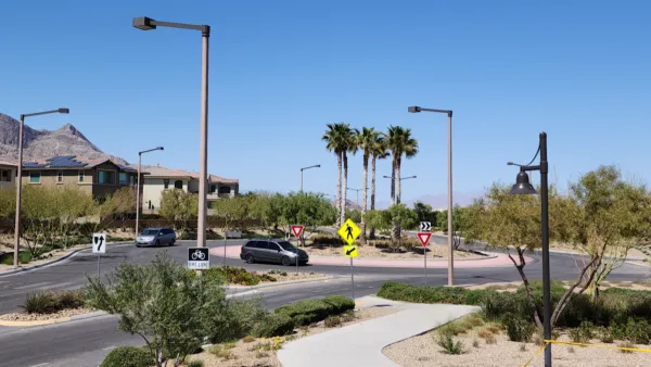
Las Vegas Uses ‘Mini-Roundabout’ for Traffic Calming
Roundabouts, commonly used in other countries, are starting to catch on in U.S. cities. They can improve traffic flow and bring efficiency benefits.

Greenways Plus Highways: A Deadly Combination
The design of intersections between major roadways and bike and pedestrian paths can have fatal consequences.
Milwaukee Road Safety Efforts Paying Off
The city is seeing fewer speeding violations after installing traffic calming measures and boosting enforcement to limit reckless driving.

National Parks Layoffs Will Cause Communities to Lose Billions
Thousands of essential park workers were laid off this week, just before the busy spring break season.

Retro-silient?: America’s First “Eco-burb,” The Woodlands Turns 50
A master-planned community north of Houston offers lessons on green infrastructure and resilient design, but falls short of its founder’s lofty affordability and walkability goals.

Delivering for America Plan Will Downgrade Mail Service in at Least 49.5 Percent of Zip Codes
Republican and Democrat lawmakers criticize the plan for its disproportionate negative impact on rural communities.

Test News Post 1
This is a summary

Test News Headline 46
Test for the image on the front page.

Balancing Bombs and Butterflies: How the National Guard Protects a Rare Species
The National Guard at Fort Indiantown Gap uses GIS technology and land management strategies to balance military training with conservation efforts, ensuring the survival of the rare eastern regal fritillary butterfly.
Urban Design for Planners 1: Software Tools
This six-course series explores essential urban design concepts using open source software and equips planners with the tools they need to participate fully in the urban design process.
Planning for Universal Design
Learn the tools for implementing Universal Design in planning regulations.
EMC Planning Group, Inc.
Planetizen
Planetizen
Mpact (formerly Rail~Volution)
Great Falls Development Authority, Inc.
HUDs Office of Policy Development and Research
NYU Wagner Graduate School of Public Service