


Mapmaker David Imus spent 2 years creating the best 3x4-foot paper wall map you'll ever see.
"David Imus worked alone on his map seven days a week for two full years. Nearly 6,000 hours in total... But Imus-a 35-year veteran of cartography who's designed every kind of map for every kind of client-did it all by himself. He used a computer (not a pencil and paper), but absolutely nothing was left to computer-assisted happenstance. Imus spent eons tweaking label positions. Slaving over font types, kerning, letter thicknesses. Scrutinizing levels of blackness. It's the kind of personal cartographic touch you might only find these days on the hand-illustrated ski-trail maps available at posh mountain resorts," writes Seth Stevenson.
"A few of his more significant design decisions: Your standard wall map will often paint the U.S. states different colors so their shapes are easily grasped. But Imus' map uses thick lines to indicate state borders and reserves the color for more important purposes-green for denser forestation, yellow for population centers. Instead of hypsometric tinting (darker colors for lower elevations, lighter colors for higher altitudes), Imus uses relief shading for a more natural portrait of U.S. terrain."
FULL STORY: The Greatest Paper Map of the United States You’ll Ever See

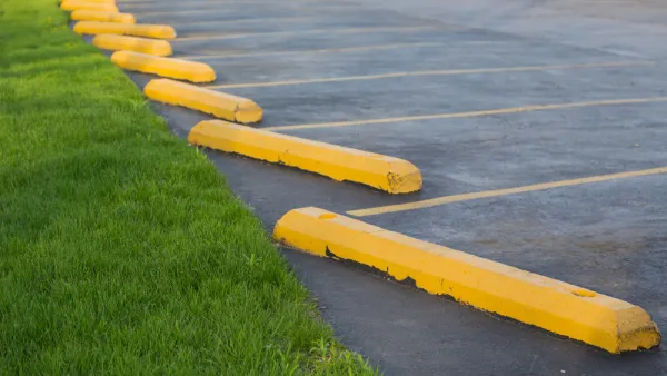
Maps: How Much of Your City is Parking?
The percentage of land dedicated to parking in the central districts of major U.S. cities ranges from 4 percent to as much as 42 percent.
Mapping Climate Impact at the Neighborhood Level
A consumption-based analysis illustrates the differences in average household emissions across census tracts.
Top Websites for Urban Planning - 2022
Every year, Planetizen collects the websites breaking new digital ground in the world of planning and related fields.

Analysis: Cybertruck Fatality Rate Far Exceeds That of Ford Pinto
The Tesla Cybertruck was recalled seven times last year.

National Parks Layoffs Will Cause Communities to Lose Billions
Thousands of essential park workers were laid off this week, just before the busy spring break season.

Retro-silient?: America’s First “Eco-burb,” The Woodlands Turns 50
A master-planned community north of Houston offers lessons on green infrastructure and resilient design, but falls short of its founder’s lofty affordability and walkability goals.

Test News Post 1
This is a summary

Analysis: Cybertruck Fatality Rate Far Exceeds That of Ford Pinto
The Tesla Cybertruck was recalled seven times last year.

Test News Headline 46
Test for the image on the front page.
Urban Design for Planners 1: Software Tools
This six-course series explores essential urban design concepts using open source software and equips planners with the tools they need to participate fully in the urban design process.
Planning for Universal Design
Learn the tools for implementing Universal Design in planning regulations.
EMC Planning Group, Inc.
Planetizen
Planetizen
Mpact (formerly Rail~Volution)
Great Falls Development Authority, Inc.
HUDs Office of Policy Development and Research
NYU Wagner Graduate School of Public Service