


According to Kate Dries, it's not the design that sets apart the plans for Bloomingdale Trail, Chicago's elevated railway to park conversion. The way the project has evolved sets it apart from its east coast cousin and prior efforts.
According to Dries, partnerships between government agencies and community groups, involvement of community members in every stage of the planning and design process, and the Trail's intended use as a local resource, rather than tourist destination, sets Bloomingdale Trail apart from its east coast cousin, and Chicago's typical top-down approach to planning.
Whether reflecting reality or a bit of explicatory exaggeration, Dries distinguishes Bloomingdale Trail's extensive community engagement with the High Line's definition "by a mass amount of money donated by high profile
celebrities." She also contrasts the Chicago park's local orientation with the High Line's function as "a tourist destination for high living,
not a park meant to integrate into normal life."
However, it's with Chicago's typical approach to planning that the largest discrepancy may lie. "[T]his is a project that, by its nature, could not have
happened without endless community input and collaboration -- a far cry
from the way city planning and development has been approached in
decades past," says Dries, "and proof that perhaps some effort towards transparency in
goverment [sic] is working."
FULL STORY: The Bloomingdale Trail reveals Chicago's idea of grand city planning

Chicago's 606 Bike Path Made Gentrification Inevitable, Expert Claims
Because the rails to trails project left housing up to the market, rising rents were inevitable, claims a new report.
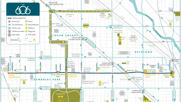
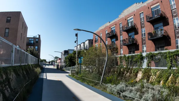
Meet the 606: Chicago's New Elevated Bikeway and Park
Following in the footsteps of the High Line in New York City, Chicago opened a 2.7-mile elevated park, which has already been extremely popular in its first week. Here we round up the initial reactions to The 606, as the new park is called.
Bloomingdale Trail Gets New Name and Final Plan
Final plans for what will become the longest elevated park in the world where unveiled this week in Chicago. The 2.7-mile rail-to-trail conversion has been branded as The 606, a nod to the zip code digits shared by the neighborhoods along its route.

National Parks Layoffs Will Cause Communities to Lose Billions
Thousands of essential park workers were laid off this week, just before the busy spring break season.

Retro-silient?: America’s First “Eco-burb,” The Woodlands Turns 50
A master-planned community north of Houston offers lessons on green infrastructure and resilient design, but falls short of its founder’s lofty affordability and walkability goals.

Delivering for America Plan Will Downgrade Mail Service in at Least 49.5 Percent of Zip Codes
Republican and Democrat lawmakers criticize the plan for its disproportionate negative impact on rural communities.

Test News Post 1
This is a summary

Test News Headline 46
Test for the image on the front page.

Balancing Bombs and Butterflies: How the National Guard Protects a Rare Species
The National Guard at Fort Indiantown Gap uses GIS technology and land management strategies to balance military training with conservation efforts, ensuring the survival of the rare eastern regal fritillary butterfly.
Urban Design for Planners 1: Software Tools
This six-course series explores essential urban design concepts using open source software and equips planners with the tools they need to participate fully in the urban design process.
Planning for Universal Design
Learn the tools for implementing Universal Design in planning regulations.
EMC Planning Group, Inc.
Planetizen
Planetizen
Mpact (formerly Rail~Volution)
Great Falls Development Authority, Inc.
HUDs Office of Policy Development and Research
NYU Wagner Graduate School of Public Service