


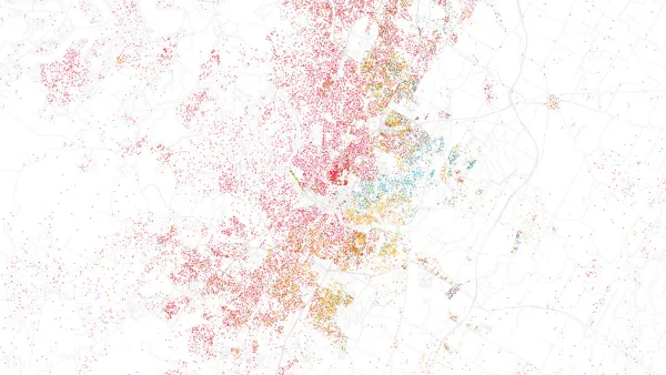
A joint project by technology company Esri and the city of San Francisco shows the promising confluence of open data and innovative visualization techniques.
Ariel Schwartz looks at the successful collaboration that created the San Francisco Urban Revitalization Map,
"a visualization of the city's explosive
growth, and how it has affected different neighborhoods." Created using open data that captures the past 12 years of San Francisco's growth, the animated map shows the city's transformation in vivid colors.
"The map doesn't venture outside San Francisco," says Schwartz, "but there's no reason why
other cities with open data policies can't do similar projects. For
Esri, this is just the beginning--the company is considering doing a
mapathon or maphacking event where data scientists and cartographers get
together to see what they can do with open data. 'We want to show that
web mapping is growing up,' explains [Esri's Jim] Young."
FULL STORY: Visualizing San Francisco’s Urban Growth With Open Data


Washington DC Launches Open Data Chatbot
City data is now available literally at the public’s fingertips, no data analytics skills required.
Esri App Makes Data Visualization Easy
A wealth of pre-authored policy maps lets users access data to explore public policy issues.
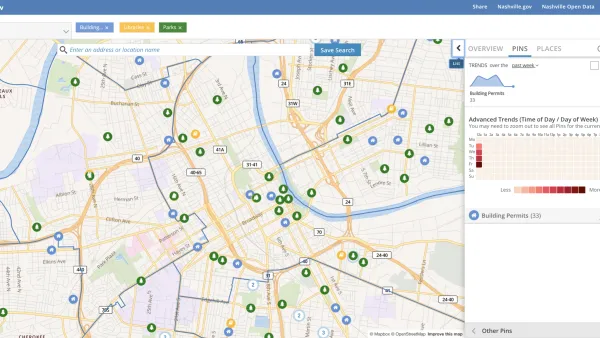
Presenting Municipal Data in an Interactive Map, Nashville Style
The city of Nashville launched the NashView interactive data map earlier this month.

National Parks Layoffs Will Cause Communities to Lose Billions
Thousands of essential park workers were laid off this week, just before the busy spring break season.

Retro-silient?: America’s First “Eco-burb,” The Woodlands Turns 50
A master-planned community north of Houston offers lessons on green infrastructure and resilient design, but falls short of its founder’s lofty affordability and walkability goals.

Delivering for America Plan Will Downgrade Mail Service in at Least 49.5 Percent of Zip Codes
Republican and Democrat lawmakers criticize the plan for its disproportionate negative impact on rural communities.

Test News Post 1
This is a summary

Test News Headline 46
Test for the image on the front page.

Balancing Bombs and Butterflies: How the National Guard Protects a Rare Species
The National Guard at Fort Indiantown Gap uses GIS technology and land management strategies to balance military training with conservation efforts, ensuring the survival of the rare eastern regal fritillary butterfly.
Urban Design for Planners 1: Software Tools
This six-course series explores essential urban design concepts using open source software and equips planners with the tools they need to participate fully in the urban design process.
Planning for Universal Design
Learn the tools for implementing Universal Design in planning regulations.
EMC Planning Group, Inc.
Planetizen
Planetizen
Mpact (formerly Rail~Volution)
Great Falls Development Authority, Inc.
HUDs Office of Policy Development and Research
NYU Wagner Graduate School of Public Service