


For those that dream of traveling the length of the Golden State without getting behind the wheel of an automobile, a new map shows the interconnected system of trains and buses that can get you from San Diego to Eureka and in-between.
Aaron Bialick shares the new California Rail Map, a map of transit throughout the Golden State. Created by Alfred Twu and his team of cartographers, the map features “both intracity and regional rail lines as well as connecting buses, proving once and for all that it’s possible to get to almost anywhere in the state on public transit,” says Twu.
"The map ties together networks for Amtrak, BART, Muni, VTA, Caltrain, Altamont Commuter Express, Sacramento Regional Transit, San Diego North County Transit District (NCTD), San Diego Trolley, LA Metro, and Metrolink, as well as key bus and ferry connections."
And though the map includes more than 500 destinations reachable by train or connecting bus or ferry, you may want to time your trip with Google Maps before you plan to travel between Palm Springs and Yosemite.
FULL STORY: New California Transit Map Simplifies Car-Free Travel Across the State


Mapping Climate Impact at the Neighborhood Level
A consumption-based analysis illustrates the differences in average household emissions across census tracts.
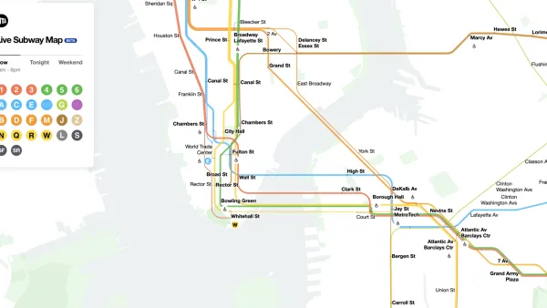
The New New York Subway Map Works in Real Time
There's a new chapter, and maybe an end, for the "Great Subway Map Debate."
Coming Soon: A New Transit Map for Philadelphia
Transit is getting a new look.

Analysis: Cybertruck Fatality Rate Far Exceeds That of Ford Pinto
The Tesla Cybertruck was recalled seven times last year.

National Parks Layoffs Will Cause Communities to Lose Billions
Thousands of essential park workers were laid off this week, just before the busy spring break season.

Retro-silient?: America’s First “Eco-burb,” The Woodlands Turns 50
A master-planned community north of Houston offers lessons on green infrastructure and resilient design, but falls short of its founder’s lofty affordability and walkability goals.

Test News Post 1
This is a summary

Analysis: Cybertruck Fatality Rate Far Exceeds That of Ford Pinto
The Tesla Cybertruck was recalled seven times last year.

Test News Headline 46
Test for the image on the front page.
Urban Design for Planners 1: Software Tools
This six-course series explores essential urban design concepts using open source software and equips planners with the tools they need to participate fully in the urban design process.
Planning for Universal Design
Learn the tools for implementing Universal Design in planning regulations.
EMC Planning Group, Inc.
Planetizen
Planetizen
Mpact (formerly Rail~Volution)
Great Falls Development Authority, Inc.
HUDs Office of Policy Development and Research
NYU Wagner Graduate School of Public Service