


An enterprising blogger has produced a slew of urban maps with an overlay of publicly available data on exercise routes. In addition to being fetching, the patterns revealed show how runners make use of the public realm.
Dr. Nathan Yau, PhD, who runs the FlowingDate blog, has produced a series of maps for cities both large and small around the country, using the app RunKeeper to source data. The app Strava, for bikers, according to Dr. Yau, would also work in the same way and has been used to good effect before (although on an individual basis).
As Dr. Yau aptly points out: “[the visualization] can be useful to the data collectors to plan future workouts or even city planners who make sure citizens have proper bike lanes and running paths.”
And here’s Dr. Yau’s initial takeaway about what the maps say about how runners make use of the public realm: “If there's one quick (and expected) takeaway, it's that people like to run by the water and in parks, probably to get away from cars and the scenery. In the smaller inland cities, there seem to be a few high-traffic roads with less running elsewhere.”
FULL STORY: Where people run

Mapped: Every Building in the United States
Using data from Microsoft, the New York Times has published an online map showing the placement of every building in the country, in a simple black and white format.

California Evictions Much Faster and More Frequent Than Previously Thought
About 500,000 tenants face eviction every year—triple previous estimates. And over a million may be involuntary displaced despite never making it to court.
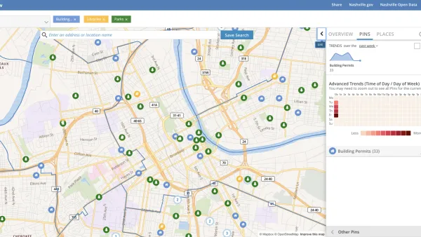
Presenting Municipal Data in an Interactive Map, Nashville Style
The city of Nashville launched the NashView interactive data map earlier this month.

National Parks Layoffs Will Cause Communities to Lose Billions
Thousands of essential park workers were laid off this week, just before the busy spring break season.

Retro-silient?: America’s First “Eco-burb,” The Woodlands Turns 50
A master-planned community north of Houston offers lessons on green infrastructure and resilient design, but falls short of its founder’s lofty affordability and walkability goals.

Delivering for America Plan Will Downgrade Mail Service in at Least 49.5 Percent of Zip Codes
Republican and Democrat lawmakers criticize the plan for its disproportionate negative impact on rural communities.

Test News Post 1
This is a summary

Test News Headline 46
Test for the image on the front page.

Balancing Bombs and Butterflies: How the National Guard Protects a Rare Species
The National Guard at Fort Indiantown Gap uses GIS technology and land management strategies to balance military training with conservation efforts, ensuring the survival of the rare eastern regal fritillary butterfly.
Urban Design for Planners 1: Software Tools
This six-course series explores essential urban design concepts using open source software and equips planners with the tools they need to participate fully in the urban design process.
Planning for Universal Design
Learn the tools for implementing Universal Design in planning regulations.
EMC Planning Group, Inc.
Planetizen
Planetizen
Mpact (formerly Rail~Volution)
Great Falls Development Authority, Inc.
HUDs Office of Policy Development and Research
NYU Wagner Graduate School of Public Service