


A political battle over the Ozark National Scenic Riverways—the largest federal park in Missouri—is heating up. The debate pressures a crucial distinction: how much are protected open spaces for people, and how much are they for protecting.
The federal government recently ended public comment for the long-range management plan for the Ozark National Scenic Riverways, home to the Current and Jacks Fork rivers and located just three hours southwest of St. Louis. The park's 134 miles of spring-fed river and 80,000 acres of wilderness is a popular destination for outdoor enthusiasts.
Todd C. Frankel reports on the two sides in the debate. "The problem is that some residents living near the rivers believe any new restrictions would hurt tourism and restrict the water access they’ve enjoyed for generations," reports Frankel. That side has the political support of U.S. Rep. Jason Smith, R-Salem, who opposes new restrictions in the federal park, which runs through his district.
On the other side: "environmental and conservation groups, plus some people who live farther away and use the rivers for recreation, believe tighter rules are needed to protect the waterways from degradation." In fact, "[three] years ago, the advocacy group American Rivers listed the Ozark waterways among the nation’s 10 most endangered rivers."
The National Park Service has already announced its preference for new restrictions on motorboats, horseback riders and ATVs. Rep. Smith has responded by introducing two bills in the House, including one that would transfer the park back to state control.
FULL STORY: Fight over Ozark rivers isn't waiting for park service's decision


National Parks Layoffs Will Cause Communities to Lose Billions
Thousands of essential park workers were laid off this week, just before the busy spring break season.
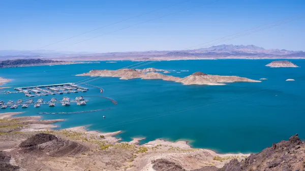
Illegal Roads Threaten Lake Mead’s Shoreline
As visitors seek out ways to reach the lake’s increasingly distant shoreline, officials say illegally created roads are damaging environmental and cultural resources and leading to hundreds of calls for rescue for stranded vehicles.
Regenerating and Healing Land Through Parks
Through thoughtful planning and restoration efforts, parks can help heal degraded land, meeting multiple community needs, improving soil quality, restoring native vegetation, and creating habitats for wildlife.
National Parks Layoffs Will Cause Communities to Lose Billions
Thousands of essential park workers were laid off this week, just before the busy spring break season.

Retro-silient?: America’s First “Eco-burb,” The Woodlands Turns 50
A master-planned community north of Houston offers lessons on green infrastructure and resilient design, but falls short of its founder’s lofty affordability and walkability goals.

Delivering for America Plan Will Downgrade Mail Service in at Least 49.5 Percent of Zip Codes
Republican and Democrat lawmakers criticize the plan for its disproportionate negative impact on rural communities.

Test News Post 1
This is a summary

Test News Headline 46
Test for the image on the front page.

Balancing Bombs and Butterflies: How the National Guard Protects a Rare Species
The National Guard at Fort Indiantown Gap uses GIS technology and land management strategies to balance military training with conservation efforts, ensuring the survival of the rare eastern regal fritillary butterfly.
Urban Design for Planners 1: Software Tools
This six-course series explores essential urban design concepts using open source software and equips planners with the tools they need to participate fully in the urban design process.
Planning for Universal Design
Learn the tools for implementing Universal Design in planning regulations.
EMC Planning Group, Inc.
Planetizen
Planetizen
Mpact (formerly Rail~Volution)
Great Falls Development Authority, Inc.
HUDs Office of Policy Development and Research
NYU Wagner Graduate School of Public Service