


After a failed attempt at similarly broad land use regulations failed in 2011, the Minnesota Department of Natural Resources is again undertaking an outreach process to create land use regulations along 72 miles of the Mississippi River.
The Minnesota Department of Natural Resources is halfway through a two-year process to "revamp land-use rules along the stretch of the Mississippi River that runs through the Twin Cities area," according to Jim Anderson. The process "is once again pitting cities and development interests against environmental concerns."
"[The] rules that would affect 21 cities, five counties and four townships along a 72-mile stretch of river from Dayton to Hastings."
In St. Paul, for instance, "[almost] 2,000 buildings and nearly 3,000 parcels of land in the city would come under new construction limits near bluffs and steep slopes along the river."
The cities want local control over land use regulations, as do developers, while environmentalists would like to limit the amount of exceptions on the table. Another regulation under consideration that has provoked the ire of environmentalist river proponents: "The rules weaken scenic protections by allowing taller buildings along the river, including some of its most beautiful stretches: the gorge near the University of Minnesota, West Side Flats, Pine Bend Bluffs in Inver Grove Heights and the bluff lands of eastern Dakota and southern Washington counties."
FULL STORY: DNR land-use rules draw concerns along the Mississippi riverfront

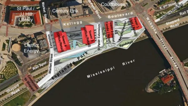
Details of St. Paul Riverfront Plans Emerge
A plan to remake the St. Paul riverfront, and potentially revitalize the downtown office market, took its first steps forward this week.

Controversial Green Neighborhood to Rise on Former Auto Plant Site
Plans for a sizable eco-friendly development on the site of St. Paul's Twin Cities Assembly Plant have drawn support from many, including the city's young mayor. But density opponents remain unconvinced.
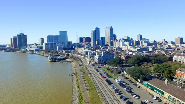
New Orleans Closes Gap in Historic Riverfront Park Plan
New Orleans could create the largest stretch of public riverfront in the U.S., thanks to a public land swap.

National Parks Layoffs Will Cause Communities to Lose Billions
Thousands of essential park workers were laid off this week, just before the busy spring break season.

Retro-silient?: America’s First “Eco-burb,” The Woodlands Turns 50
A master-planned community north of Houston offers lessons on green infrastructure and resilient design, but falls short of its founder’s lofty affordability and walkability goals.

Delivering for America Plan Will Downgrade Mail Service in at Least 49.5 Percent of Zip Codes
Republican and Democrat lawmakers criticize the plan for its disproportionate negative impact on rural communities.

Test News Post 1
This is a summary

Test News Headline 46
Test for the image on the front page.

Balancing Bombs and Butterflies: How the National Guard Protects a Rare Species
The National Guard at Fort Indiantown Gap uses GIS technology and land management strategies to balance military training with conservation efforts, ensuring the survival of the rare eastern regal fritillary butterfly.
Urban Design for Planners 1: Software Tools
This six-course series explores essential urban design concepts using open source software and equips planners with the tools they need to participate fully in the urban design process.
Planning for Universal Design
Learn the tools for implementing Universal Design in planning regulations.
EMC Planning Group, Inc.
Planetizen
Planetizen
Mpact (formerly Rail~Volution)
Great Falls Development Authority, Inc.
HUDs Office of Policy Development and Research
NYU Wagner Graduate School of Public Service