


New in flaneur-enabling technology: a team of intrepid aesthetes in Barcelona is working on a new app that would advance GPS mapping tools by providing the most beautiful route to a destination, rather than the shortest or least congested route.
Those of us obsessed with the navigation and mapping powers of route-calculating apps will soon have more aesthetically-minded options for finding a route across town, thanks to the work of Daniele Quercia and friends at Yahoo Labs in Barcelona, Spain. An article in the MIT Technology Review explains that Quercia and team "have worked out how to measure the 'beauty' of specific locations within cities and then designed an algorithm that automatically chooses a route between two locations in a way that maximizes the beauty along it. 'The goal of this work is to automatically suggest routes that are not only short but also emotionally pleasant,' they say."
The team used a number of methods to collect data on which places in London are more, shall we say, fetching. First there was crowdsourcing via public opinion: "Quercia and co begin by creating a database of images of various parts of the center of London taken from Google Street View and Geograph, both of which have reasonably consistent standards of images. They then crowdsourced opinions about the beauty of each location using a website called UrbanGems.org." (StreetSeen is a similar system for crowd sourcing public reaction to cityscapes.)
The second involved scraping data from photo sharing sites like Flickr: "Crowdsourcing opinion for every possible location in a city is clearly a time-consuming and potentially expensive business. So Quercia and co have automated this process using photos from Flickr and the data and tags attached to them," and, "[factors] that turn out to be a good indicator of beauty are things like the number of pictures taken of a particular scene and comments associated with positive emotions."
As for choosing the more beautiful route, it might just take a little longer: "Quercia and co say that on average these routes turn out to be just 12 percent longer than the shortest routes, which makes them reasonable alternatives for a pedestrian."
FULL STORY: Forget the Shortest Route Across a City; New Algorithm Finds the Most Beautiful

What's Missed When Taking the Scenic Route?
An app that plots the most beautiful route across cities made news earlier this month, but one commenter worries about how taking the more scenic route could make it harder to improve quality of life in the "less-than-scenic" sections of cities.
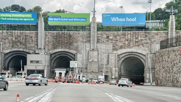
Waze Outfits NYC Tunnels with Beacons for Underground Navigation
The tech is part of a public-private partnership meant to improve connectivity to Waze and other navigation apps from underground.
An App for Navigating While Walking
A new app called Walc makes navigating while walking easier to do. Even more ambitiously, Walc aims to make it easier to make the choice to walk, rather than drive.

National Parks Layoffs Will Cause Communities to Lose Billions
Thousands of essential park workers were laid off this week, just before the busy spring break season.

Retro-silient?: America’s First “Eco-burb,” The Woodlands Turns 50
A master-planned community north of Houston offers lessons on green infrastructure and resilient design, but falls short of its founder’s lofty affordability and walkability goals.

Delivering for America Plan Will Downgrade Mail Service in at Least 49.5 Percent of Zip Codes
Republican and Democrat lawmakers criticize the plan for its disproportionate negative impact on rural communities.

Test News Post 1
This is a summary

Test News Headline 46
Test for the image on the front page.

Balancing Bombs and Butterflies: How the National Guard Protects a Rare Species
The National Guard at Fort Indiantown Gap uses GIS technology and land management strategies to balance military training with conservation efforts, ensuring the survival of the rare eastern regal fritillary butterfly.
Urban Design for Planners 1: Software Tools
This six-course series explores essential urban design concepts using open source software and equips planners with the tools they need to participate fully in the urban design process.
Planning for Universal Design
Learn the tools for implementing Universal Design in planning regulations.
EMC Planning Group, Inc.
Planetizen
Planetizen
Mpact (formerly Rail~Volution)
Great Falls Development Authority, Inc.
HUDs Office of Policy Development and Research
NYU Wagner Graduate School of Public Service