


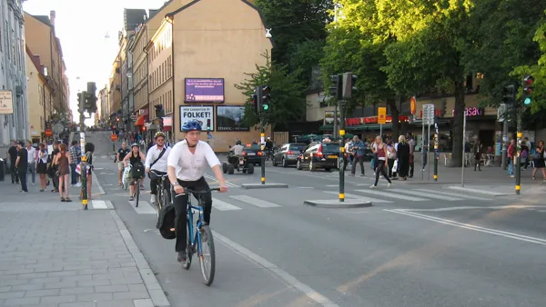
A new study indicates that the safest urban streets have lanes that measure 10-10.5 feet wide. Narrower and wider lanes have higher crash frequencies, and wider lanes have higher crash severity.

The "forgiving highway" approach to traffic engineering holds that wider is safer when it comes to street design. After decades of adherence to these standards, American cities are now criss-crossed by streets with 12-foot wide lanes. As Walkable City author Jeff Speck argued in a column last year, this is actually terrible for public safety and the pedestrian environment.
A new study reinforces the argument that cities need to reconsider lane widths and redesign streets accordingly. In a paper to be presented at the Canadian Institute of Traffic Engineers annual conference, author Dewan Masud Karim presents hard evidence that wider lanes increase risk on city streets.
Karim conducted a wide-ranging review of existing research as well as an examination of crash databases in two cities, taking into consideration 190 randomly selected intersections in Tokyo and 70 in Toronto. Looking at the crash databases, Karim found that collision rates escalate as lane widths exceed about 10.5 feet. Roads with the widest lanes—12 feet or wider—were associated with greater crash rates and higher impact speeds. Karim also found that crash rates rise as lanes become narrower than about 10 feet, though this does not take impact speeds and crash severity into account. He concluded that there is a sweet spot for lane widths on city streets, between about 10 and 10.5 feet.

The rate of side impact crashes is lowest on urban streets with lanes about 10.5 feet wide — much narrower than the standard 12 feet. Graph: Dewan Karim
In Toronto, where traffic lanes are typically wider than in Tokyo, the average crash impact speed is also 34 percent higher, Karim found, suggesting that wider lanes not only result in more crashes but in more severe crashes.
The "inevitable statistical outcome" of the "wider-is-safer approach is loss of precious life, particularly by vulnerable citizens," Karim concluded.
FULL STORY: Compelling Evidence That Wider Lanes Make City Streets More Dangerous

Rethinking Streets: New Report Illustrates Complete Streets Projects
"Rethinking Streets," a new report by the University of Oregon's Sustainable Cities Initiative, provides detailed information on 25 complete streets and streetscaping projects. It is available free in PDF and hard copy format.
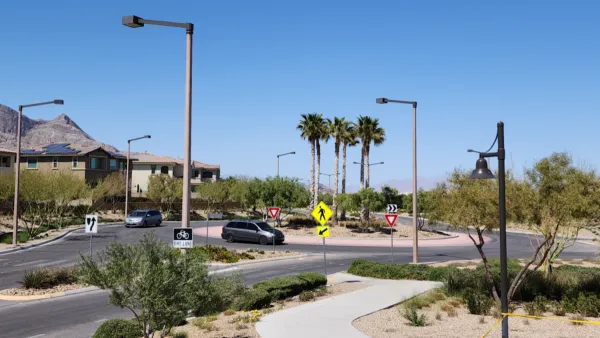
Las Vegas Uses ‘Mini-Roundabout’ for Traffic Calming
Roundabouts, commonly used in other countries, are starting to catch on in U.S. cities. They can improve traffic flow and bring efficiency benefits.
Greenways Plus Highways: A Deadly Combination
The design of intersections between major roadways and bike and pedestrian paths can have fatal consequences.

National Parks Layoffs Will Cause Communities to Lose Billions
Thousands of essential park workers were laid off this week, just before the busy spring break season.

Retro-silient?: America’s First “Eco-burb,” The Woodlands Turns 50
A master-planned community north of Houston offers lessons on green infrastructure and resilient design, but falls short of its founder’s lofty affordability and walkability goals.

Delivering for America Plan Will Downgrade Mail Service in at Least 49.5 Percent of Zip Codes
Republican and Democrat lawmakers criticize the plan for its disproportionate negative impact on rural communities.

Test News Post 1
This is a summary

Test News Headline 46
Test for the image on the front page.

Balancing Bombs and Butterflies: How the National Guard Protects a Rare Species
The National Guard at Fort Indiantown Gap uses GIS technology and land management strategies to balance military training with conservation efforts, ensuring the survival of the rare eastern regal fritillary butterfly.
Urban Design for Planners 1: Software Tools
This six-course series explores essential urban design concepts using open source software and equips planners with the tools they need to participate fully in the urban design process.
Planning for Universal Design
Learn the tools for implementing Universal Design in planning regulations.
EMC Planning Group, Inc.
Planetizen
Planetizen
Mpact (formerly Rail~Volution)
Great Falls Development Authority, Inc.
HUDs Office of Policy Development and Research
NYU Wagner Graduate School of Public Service