


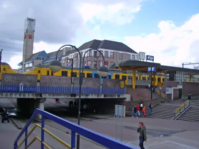
Well-known in transportation planning circles, Houten's suburban multi-modality can be found almost nowhere else. Perimeter ring roads, train access, and bike-friendly features have cut car trips down to 44 percent.
First developed in the 1980s, Houten and adjacent town South Houten now house 50,000 residents. But with 66 percent of trips made by alternate modes, Houten isn't your typical suburb.
Eric Jaffe describes how Houten's layout restricts automobile movement: "Car traffic is primarily resigned to a 'ring road' that encircles the area. Within that ring is a network of low-speed streets meant primarily for people traveling on foot or by bike (there are 80 miles of bicycle paths alone) that connect to two main intercity train stations and most of the area's schools and shops."
If they commute to other areas by car, arriving drivers "exit the ring roads onto local streets in the core of Houten that extend into individual neighborhoods but don't connect to other parts of town. To get somewhere else by car, you have to get back on the ring road."
Other multi-modal planning features include comprehensive access to commuter rail, 18-mph speed limits, and streets reserved for walkers and cyclists. "The bike paths in the extensive cycling network have their own brick red coloring. Where bike routes do cross the ring roads, underpasses separate bike and car traffic."
It's doubtful whether the Houten model could work in the USA. To one American planner, Houten betrays a "Truman Show" artificiality: "Here you find a balanced transport system but little else." To be fair, longtime Houten residents probably feel differently about their home.
FULL STORY: A Case Study in Bike-Friendly Suburban Planning


Houston Residents Respond to Mobility Questions
What could the city look like if budget and bureaucracy were no object?

Spokane Launches Safe Streets Initiative
The Washington city received a $9.6 million federal grant to fund quick-build traffic calming and bike and pedestrian infrastructure projects.
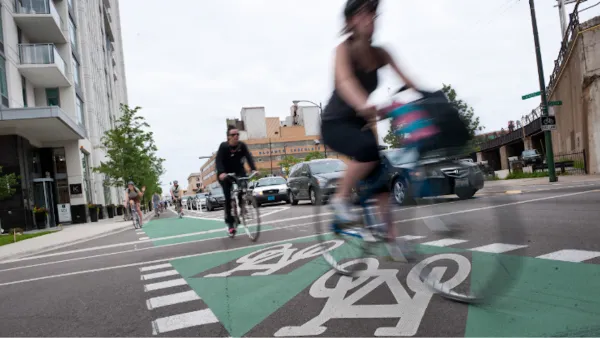
Chicago Had a Banner Year for Bike Infrastructure
The city built more bike lane miles in 2023 than in any previous year.

National Parks Layoffs Will Cause Communities to Lose Billions
Thousands of essential park workers were laid off this week, just before the busy spring break season.

Retro-silient?: America’s First “Eco-burb,” The Woodlands Turns 50
A master-planned community north of Houston offers lessons on green infrastructure and resilient design, but falls short of its founder’s lofty affordability and walkability goals.

Delivering for America Plan Will Downgrade Mail Service in at Least 49.5 Percent of Zip Codes
Republican and Democrat lawmakers criticize the plan for its disproportionate negative impact on rural communities.

Test News Post 1
This is a summary

Test News Headline 46
Test for the image on the front page.

Balancing Bombs and Butterflies: How the National Guard Protects a Rare Species
The National Guard at Fort Indiantown Gap uses GIS technology and land management strategies to balance military training with conservation efforts, ensuring the survival of the rare eastern regal fritillary butterfly.
Urban Design for Planners 1: Software Tools
This six-course series explores essential urban design concepts using open source software and equips planners with the tools they need to participate fully in the urban design process.
Planning for Universal Design
Learn the tools for implementing Universal Design in planning regulations.
EMC Planning Group, Inc.
Planetizen
Planetizen
Mpact (formerly Rail~Volution)
Great Falls Development Authority, Inc.
HUDs Office of Policy Development and Research
NYU Wagner Graduate School of Public Service