


A new online visualization tool makes it easier to read and understand data about mobile phone usage in four cities around the world, including Los Angeles and New York.
According to a post on MIT Technology Review, the SENSEable City Laboratory, part of MIT, and Ericsson, a network infrastructure technology company, have unveiled an online tool that "uses mobile phone data to visualize human activity in cities all over the world."
The ManyCities tool, as it's called, "[gathers] mobile phone data from base stations across the cities of Los Angeles, New York, London, and Hong Kong between April 2013 and January 2014. The data includes the number of calls placed, the number of text messages sent, the amount of data downloaded and uploaded and the number of data requests at 15-minute intervals."
As an example of how the ManyCities visualization tool could be used, a Los Angeles civic enthusiast might peruse the site surprised to discover that the highest density of call activity in the city is located in Koreatown and Westlake.
The team behind ManyCities also presented the tool in the July issue of the Landscape Architecture Frontiers journal.
FULL STORY: The Website That Visualizes Human Activity in Cities Across the World

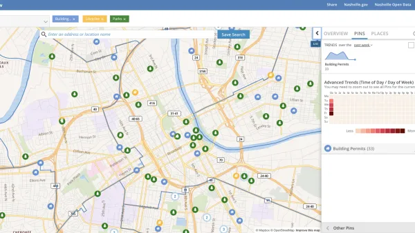
Presenting Municipal Data in an Interactive Map, Nashville Style
The city of Nashville launched the NashView interactive data map earlier this month.

DataUSA: An Intuitive Tool for Public Data
A collaboration between Deloitte, Datawheel, and MIT has produced an intuitive aesthetically-pleasing gathering point for public data in the United States. Specific locations and industries boast easy-to-read profiles.
Mapped: Every Building in the United States
Using data from Microsoft, the New York Times has published an online map showing the placement of every building in the country, in a simple black and white format.

Analysis: Cybertruck Fatality Rate Far Exceeds That of Ford Pinto
The Tesla Cybertruck was recalled seven times last year.

National Parks Layoffs Will Cause Communities to Lose Billions
Thousands of essential park workers were laid off this week, just before the busy spring break season.

Retro-silient?: America’s First “Eco-burb,” The Woodlands Turns 50
A master-planned community north of Houston offers lessons on green infrastructure and resilient design, but falls short of its founder’s lofty affordability and walkability goals.

Test News Post 1
This is a summary

Analysis: Cybertruck Fatality Rate Far Exceeds That of Ford Pinto
The Tesla Cybertruck was recalled seven times last year.

Test News Headline 46
Test for the image on the front page.
Urban Design for Planners 1: Software Tools
This six-course series explores essential urban design concepts using open source software and equips planners with the tools they need to participate fully in the urban design process.
Planning for Universal Design
Learn the tools for implementing Universal Design in planning regulations.
EMC Planning Group, Inc.
Planetizen
Planetizen
Mpact (formerly Rail~Volution)
Great Falls Development Authority, Inc.
HUDs Office of Policy Development and Research
NYU Wagner Graduate School of Public Service