


Modern maps are visual representations of millions of points of standardized data.
"As rapid change and urbanization redraw the world, someone must refresh our maps so that the two-dimensional pictures that give us a common sense of where we live reflect the dynamic, shape-shifting places around us," Emily Badger writes.
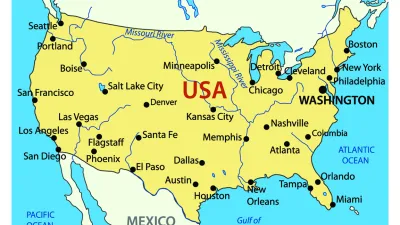
Over 12,000 new place names were identified in the United States last year, including natural landmarks, such as basins or cliffs, infrastructure, such as crossings and hospitals, and municipalities, such as newly incorporated cities. In the course of just four months this year, over 57,000 new place names in China were identified, standardized, and added to the U.S. government's database of foreign places. These data are maintained by the Board of Geographic Names (BGN), a 125-year old agency tasked with ensuring consistent spelling, transliteration, and description of the place.
As the world's population grows and expands it's terrestrial footprint, the BGN acquires information—sometimes conflicting—about the names, features, and locations of newly identified places, and these data are used to update maps.
The BGN website explains: "The original program of names standardization addressed the complex issues of domestic geographic feature names during the surge of exploration, mining, and settlement of western territories after the American Civil War. Inconsistencies and contradictions among many names, spellings, and applications became a serious problem to surveyors, map makers, and scientists who required uniform, non-conflicting geographic nomenclature." Such problems still occur for places in countries that don't have well-developed cartographic services, such as Afghanistan, or in countries where spellings and transliterations vary across regions and languages.
A quick search for the places in California containing the word "calhoun" returns one canal in Solano County, identified in 1981 as “Calhoun Cut.” A search for lakes in Minnesota crashes the computer. According to the database, there are 32 arches in Missouri, though none appear to be the iconic Gateway Arch of Saint Louis. That's because the monument does not fit the official definition of an arch, which is "a natural arch-like opening in a rock mass." By BGN standards, the 630-foot landmark is technically a park.
Badger explains why this agency's responsibilities are so critical. "Imagine the Army and the Marine Corps talking about the same town with different names in Afghanistan. Or what would happen if no one could agree on what to call Mount Hood. Or how you'd find Reston if no one had ever added it to a map."
FULL STORY: How official mapmakers keep up with a world that won’t stand still


Four New Map Books Reviewed
Looking for the perfect holiday gift for a planner? Check out these new map books.
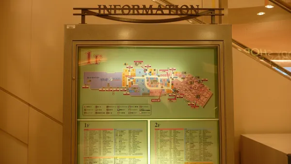
The Future of Mapping is Going Indoors
Cartographers have a new world to map, as technology opens up the interiors of malls, museums, and other large spaces to online exploration.
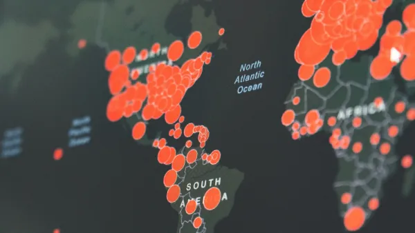
Visualizing the Coronavirus Pandemic
Mapping of the crisis is producing a fascinating and important trove of cartographic records.

Analysis: Cybertruck Fatality Rate Far Exceeds That of Ford Pinto
The Tesla Cybertruck was recalled seven times last year.

National Parks Layoffs Will Cause Communities to Lose Billions
Thousands of essential park workers were laid off this week, just before the busy spring break season.

Retro-silient?: America’s First “Eco-burb,” The Woodlands Turns 50
A master-planned community north of Houston offers lessons on green infrastructure and resilient design, but falls short of its founder’s lofty affordability and walkability goals.

Test News Post 1
This is a summary

Analysis: Cybertruck Fatality Rate Far Exceeds That of Ford Pinto
The Tesla Cybertruck was recalled seven times last year.

Test News Headline 46
Test for the image on the front page.
Urban Design for Planners 1: Software Tools
This six-course series explores essential urban design concepts using open source software and equips planners with the tools they need to participate fully in the urban design process.
Planning for Universal Design
Learn the tools for implementing Universal Design in planning regulations.
EMC Planning Group, Inc.
Planetizen
Planetizen
Mpact (formerly Rail~Volution)
Great Falls Development Authority, Inc.
HUDs Office of Policy Development and Research
NYU Wagner Graduate School of Public Service