


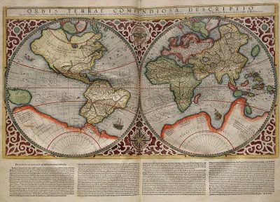
Typical world maps badly misrepresent the size of countries; a new web app shows their true scale.
The True Size Of is an interactive app that seeks to improve our skewed sense of global geography by correcting the world map.
The web app allows users to drag a country to another part of the map. The country's size and shape will change until it compares accurately to its new location.
For a little background on why "the world's most ubiquitous map" is so distorted, Liz Stinson at Wired explains:
The Mercator projection is an inherently flawed design. It exaggerates the size of countries closest to the poles while depicting size most faithfully at the equator. Though it was once a handy navigational tool for sailors, the map has instilled in the rest of us a gross misunderstanding of geography and relative country size.
FULL STORY: Fascinating App Shows You How Misleading Maps Can Be

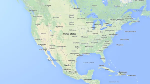
Mapped: Every Building in the United States
Using data from Microsoft, the New York Times has published an online map showing the placement of every building in the country, in a simple black and white format.
The Importance of Geographic Literacy
Maps are still an important tool in teaching kids to be global citizens.
Putting Alternative Fuel Stations on the Map
Yesterday, the U.S. Department of Energy released an interactive map displaying thousands of alternative fuel stations around the nation.

National Parks Layoffs Will Cause Communities to Lose Billions
Thousands of essential park workers were laid off this week, just before the busy spring break season.

Retro-silient?: America’s First “Eco-burb,” The Woodlands Turns 50
A master-planned community north of Houston offers lessons on green infrastructure and resilient design, but falls short of its founder’s lofty affordability and walkability goals.

Delivering for America Plan Will Downgrade Mail Service in at Least 49.5 Percent of Zip Codes
Republican and Democrat lawmakers criticize the plan for its disproportionate negative impact on rural communities.

Test News Post 1
This is a summary

Test News Headline 46
Test for the image on the front page.

Balancing Bombs and Butterflies: How the National Guard Protects a Rare Species
The National Guard at Fort Indiantown Gap uses GIS technology and land management strategies to balance military training with conservation efforts, ensuring the survival of the rare eastern regal fritillary butterfly.
Urban Design for Planners 1: Software Tools
This six-course series explores essential urban design concepts using open source software and equips planners with the tools they need to participate fully in the urban design process.
Planning for Universal Design
Learn the tools for implementing Universal Design in planning regulations.
EMC Planning Group, Inc.
Planetizen
Planetizen
Mpact (formerly Rail~Volution)
Great Falls Development Authority, Inc.
HUDs Office of Policy Development and Research
NYU Wagner Graduate School of Public Service