


An interactive map from Chicago Cityscape shows all of the city's parking lots, vacant spaces, and city-owned land. Not all of it is truly vacant, or developable, but the map shows how much scope remains for new construction.
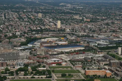
The folks over at Chicago Cityscape have upgraded their Property Finder map. According to founder Steven Vance, "The map's intention has always been straightforward: use open data to show all the land that is sitting there, across the city, but definitely concentrated in a few areas, waiting to be developed."
Categories of land include vacant spaces and portions of land owned by the city. The map also shows "over 4,600 parking lots, both surface and garage. Since the parking lots dataset comes from OpenStreetMap, where many individuals have drawn them in by hand, there are hundreds that have yet to be added."
Of course, not all the city-owned land is truly vacant, and neither is all the land labeled vacant. "The vacant land dataset, which comes from the Cook County Tax Assessor, is imperfect, too. It marks the space between buildings as vacant when they’re really not (used for driveways, garages, yards)."
Still, the map gives us an idea of where major infill development could occur. The majority of city-owned and vacant property is located in lower-income neighborhoods, both on the South Side (mostly west of the Dan Ryan Expressway), and west of downtown around Garfield Park and Lawndale. Parking lots are thickly spread south and west of the Loop, and along the river to the north.
FULL STORY: Look at all that developable land in the city

Chicago Planning Department Rejects 'Overparked' Six Corners Proposal
In a decision that is still impossible in most of the country, Chicago's Department of Planning and Development is requiring housing and reduced surface parking to approve a retail project.

Keeping Colorado Land from Development Could Cost $5 Million
In Golden, Colorado, residents want to keep a parcel of land as open space, but it could come with a hefty price tag.
Mapped: Chicago's Shrinking Middle Class
In 1970, half of the city's census tracts were middle-income. Now, only 16 percent of them remain so. Polarization between the well-off and the poor essentially splits the city in two.

Analysis: Cybertruck Fatality Rate Far Exceeds That of Ford Pinto
The Tesla Cybertruck was recalled seven times last year.

National Parks Layoffs Will Cause Communities to Lose Billions
Thousands of essential park workers were laid off this week, just before the busy spring break season.

Retro-silient?: America’s First “Eco-burb,” The Woodlands Turns 50
A master-planned community north of Houston offers lessons on green infrastructure and resilient design, but falls short of its founder’s lofty affordability and walkability goals.

Test News Post 1
This is a summary

Analysis: Cybertruck Fatality Rate Far Exceeds That of Ford Pinto
The Tesla Cybertruck was recalled seven times last year.

Test News Headline 46
Test for the image on the front page.
Urban Design for Planners 1: Software Tools
This six-course series explores essential urban design concepts using open source software and equips planners with the tools they need to participate fully in the urban design process.
Planning for Universal Design
Learn the tools for implementing Universal Design in planning regulations.
EMC Planning Group, Inc.
Planetizen
Planetizen
Mpact (formerly Rail~Volution)
Great Falls Development Authority, Inc.
HUDs Office of Policy Development and Research
NYU Wagner Graduate School of Public Service