


State Route 37 is a vital highway connecting four North Bay counties plagued by two unrelated problems: chronic flooding during high tides and traffic congestion. Fixing the problem will set a precedent for Bay Area climate adaptation.
The 21-mile highway, known as SR 37, connects the counties of Marin, Sonoma, Solano, and Napa while skirting the San Pablo Bay. It suffers two unrelated problems: flooding caused by high tides and traffic congestion.
Fixing the highway's problems "to avoid its potential loss in the next 20 years because of flooding will be our first regional foray into adapting to sea level rise — an issue that will threaten most of our shoreline infrastructure, coastal ecosystems and population centers," write University of California at Davis ecologist, Fraser Shilling, co-director of the Road Ecology Center, and Steven Moore, a civil engineer and vice chair of the State Water Resources Control Board, in this cover story for the Insight section of Sunday's San Francisco Chronicle.
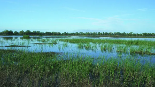
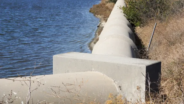
Today the highway is built atop a berm, an outdated method of building roads across marshes and waterways that constricts the ability of the bay to improve water quality by filtering out pollutants, produce more fish and wildlife, and absorb floods.
Currently, some are advocating for raising the highway [$1.3 billion] in its current location, with the primary goal of increasing traffic flows, at least in the short term. Although cheaper than the bridge-causeway alternative [$4 billion], the berm approach misses the more holistic opportunities of reconnecting marshlands to the bay and taking advantage of the flood-absorbing capacity of thousands of acres of these publicly owned wetlands.
One is reminded of the catastrophic damage done by Hurricane Harvey to Houston last month, caused in part by development choices made by the city and region. Mitigating flooding by connecting the marshes to the bay by either the causeway, which would still impact marshes, or what Shilling and Moore call the North Bay Bridge, may enable the project to tap the 2016 regional Measure AA funds for wetland restoration and adaptation to sea level rise.
Tolling an option
In 2015, the congestion management agencies of the four affected counties "agreed to form a partnership ... to develop an expedited funding, financing and project implementation strategy for the reconstruction of SR 37 to withstand rising seas and storm surges while improving mobility and safety along the route," according to the Sonoma County Transportation Authority.
A post last May indicated they are explore financing options which reportedly include the use of tolling and public-private partnerships.
FULL STORY: Rebuild State Route 37 to address sea level rise and traffic

Bay Area Developments at Risk From Sea Level Rise
A controversial proposed housing development in Newark exemplifies the struggle between increasing housing supply and protecting vulnerable shoreline communities from flooding.
Bay Area to Create Regional Plan for Sea-Level Rise
California wants the region to work together to deal with the impacts of climate change.
An In-Depth Look at Sea Level Rise in the San Francisco Bay Area
The San Francisco Chronicle gives feature-length, in-depth treatment to the looming dangers of sea level rise, which are more likely to encroach on the built and natural environments of the Bay Area with every passing year.

Analysis: Cybertruck Fatality Rate Far Exceeds That of Ford Pinto
The Tesla Cybertruck was recalled seven times last year.

National Parks Layoffs Will Cause Communities to Lose Billions
Thousands of essential park workers were laid off this week, just before the busy spring break season.

Retro-silient?: America’s First “Eco-burb,” The Woodlands Turns 50
A master-planned community north of Houston offers lessons on green infrastructure and resilient design, but falls short of its founder’s lofty affordability and walkability goals.

Test News Post 1
This is a summary

Analysis: Cybertruck Fatality Rate Far Exceeds That of Ford Pinto
The Tesla Cybertruck was recalled seven times last year.

Test News Headline 46
Test for the image on the front page.
Urban Design for Planners 1: Software Tools
This six-course series explores essential urban design concepts using open source software and equips planners with the tools they need to participate fully in the urban design process.
Planning for Universal Design
Learn the tools for implementing Universal Design in planning regulations.
EMC Planning Group, Inc.
Planetizen
Planetizen
Mpact (formerly Rail~Volution)
Great Falls Development Authority, Inc.
HUDs Office of Policy Development and Research
NYU Wagner Graduate School of Public Service