


The location of a proposed crossing in the fast-growing southwest Houston suburbs could have a significant impact on the area's development.
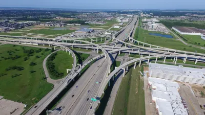
The decision over where to place a new intersection has become a major debate in Fort Bend County, just west of Houston. According to an article by Dug Begley, "Where county leaders eventually decide to put that intersection will have an impact far beyond the typical road, with potential ripple effects on the cost to build the toll roads, the types of development that will replace that tranquil farmland and how much philanthropic money comes to Fort Bend County. The land closest to the intersection is expected to have a future worth of $500 million."
The crossing was originally planned for an area located on land owned by the George Foundation, but last October, the Commissioners Court voted to move the future intersection, giving developer The Signorelli Company the option to buy the land under the new proposed site. While the crossing won't be built for years, the current development of new neighborhoods and roads, including a 4,700-acre development by Signorelli scheduled to break ground later this year, will have an impact on the eventual location.
As Begley notes, "What George Foundation officials envision, however, is a project that will take much longer to sprout, but could become far larger and more profitable for county residents. It also would pour tens of millions into the charity’s bank account that eventually could be used to reduce homelessness, award scholarships for hundreds of college-bound and nursing students, provide materials for disaster relief and invest in local public health programs."
Commissioners involved in the recent decision have so far declined to comment on their reasoning. The issue remains unresolved, as the state and county plans for the Grand Parkway and its intersection with the Fort Bend Tollway remain unaligned.
FULL STORY: A fight has erupted over where to put a Grand Parkway intersection. Millions of dollars are at stake.


Interactive Map Highlights Freeway-Related Displacement in Houston
A new map illustrates the neighborhoods and buildings that were razed to make way for freeways and estimates the number of people displaced by roadways.
Reimagining the Space Beneath Houston’s Freeways
Opportunities abound for Houston to capitalize on otherwise unused space beneath its wide network of freeways.
Report: Bike Lanes Can't Make up for New Roads
If California wants to meet its climate goals, the state must stop funding its myriad road construction and expansion projects.

National Parks Layoffs Will Cause Communities to Lose Billions
Thousands of essential park workers were laid off this week, just before the busy spring break season.

Retro-silient?: America’s First “Eco-burb,” The Woodlands Turns 50
A master-planned community north of Houston offers lessons on green infrastructure and resilient design, but falls short of its founder’s lofty affordability and walkability goals.

Delivering for America Plan Will Downgrade Mail Service in at Least 49.5 Percent of Zip Codes
Republican and Democrat lawmakers criticize the plan for its disproportionate negative impact on rural communities.

Test News Post 1
This is a summary

Test News Headline 46
Test for the image on the front page.

Balancing Bombs and Butterflies: How the National Guard Protects a Rare Species
The National Guard at Fort Indiantown Gap uses GIS technology and land management strategies to balance military training with conservation efforts, ensuring the survival of the rare eastern regal fritillary butterfly.
Urban Design for Planners 1: Software Tools
This six-course series explores essential urban design concepts using open source software and equips planners with the tools they need to participate fully in the urban design process.
Planning for Universal Design
Learn the tools for implementing Universal Design in planning regulations.
EMC Planning Group, Inc.
Planetizen
Planetizen
Mpact (formerly Rail~Volution)
Great Falls Development Authority, Inc.
HUDs Office of Policy Development and Research
NYU Wagner Graduate School of Public Service