


Austin's Visio Zero program is hard at work, making significant changes to some of the city's most dangerous intersections.
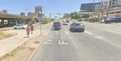
The Austin Transportation Department has begun work on safety improvements at some of the city’s dangerous intersections—located in Downtown Austin between Interstate 35 frontage roads and Seventh and Eighth streets.
Sarah Asch reports on the safety projects for the Austin American-Statesman, noting that the intersections were identified for upgrades by the city’s Vision Zero plan, and are funded by the city’s 2016 mobility bond [pdf].
“The projects include curb and ramp improvements to make the area safer for pedestrians on Seventh Street on both sides of the highway. The intersection between Seventh Street and the southbound I-35 frontage road will also have a new section of bike lane installed,” reports Asch.
“In the intersection between Seventh Street and the northbound frontage road, the city plans to install a high-visibility crosswalk, which uses an unusual pattern to be more visible to pedestrians and drivers, and a raised median island to improve pedestrian safety. Another high-visibility crosswalk will be installed one block up at the intersection between Eighth Street and the northbound frontage road.”
More details on the projects and Austin’s Vision Zero program are included in the source article below.
FULL STORY: City remaking high-crash intersections on some downtown Austin streets

Austin Left Turn Improvements Cut Serious Crashes by Half
Changes to left turn infrastructure and signal timing led to a 47 to 72 percent drop in fatal and serious injury crashes.
Report: Vision Zero Saving Lives in Austin
Safety improvements at major intersections led to a 22 percent reduction in deaths and severe injuries and saved the city over $28 million.
Report: Austin’s State Roads Deadlier Than City Roads
Traffic fatalities and serious injuries grew on state-owned roads in the Texas capital, even as city-owned streets saw death rates plateau.

National Parks Layoffs Will Cause Communities to Lose Billions
Thousands of essential park workers were laid off this week, just before the busy spring break season.

Retro-silient?: America’s First “Eco-burb,” The Woodlands Turns 50
A master-planned community north of Houston offers lessons on green infrastructure and resilient design, but falls short of its founder’s lofty affordability and walkability goals.

Delivering for America Plan Will Downgrade Mail Service in at Least 49.5 Percent of Zip Codes
Republican and Democrat lawmakers criticize the plan for its disproportionate negative impact on rural communities.

Test News Post 1
This is a summary

Test News Headline 46
Test for the image on the front page.

Balancing Bombs and Butterflies: How the National Guard Protects a Rare Species
The National Guard at Fort Indiantown Gap uses GIS technology and land management strategies to balance military training with conservation efforts, ensuring the survival of the rare eastern regal fritillary butterfly.
Urban Design for Planners 1: Software Tools
This six-course series explores essential urban design concepts using open source software and equips planners with the tools they need to participate fully in the urban design process.
Planning for Universal Design
Learn the tools for implementing Universal Design in planning regulations.
EMC Planning Group, Inc.
Planetizen
Planetizen
Mpact (formerly Rail~Volution)
Great Falls Development Authority, Inc.
HUDs Office of Policy Development and Research
NYU Wagner Graduate School of Public Service