


The creator of the TED conference has teamed up with Esri to develop an innovative interactive exhibit and online mapping tool to compare 16 global cities along 16 data points, including: population density, open space, and traffic.
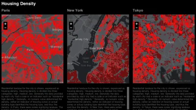
Richard Saul Wurman, the creator of the TED conference, has been interested in being able to compare cities at the same scale for more than 50 years. But only recently was he able to create a means to effectively, and attractively, display comparative patterns.
Wurman, Jon Kamen of Radical Media, and Esri president Jack Dangermond, have together created the Urban Observatory, "an immersive exhibit featuring standardized comparative data on over 16 cities. Zoom in on one city map and other cities will simultaneously zoom in at the same scale, making it possible to compare data on traffic density, vegetation, residential land use, and so on," says Ariel Schwartz.
"The Observatory features 16 data sets in five categories: work, movement, people, public, and systems. 'It’s shocking that it hasn’t been done 40 years ago, 50 years ago,' says Wurman."
FULL STORY: The Urban Observatory: A New Way To Compare Cities, From The Creator Of TED


Washington DC Launches Open Data Chatbot
City data is now available literally at the public’s fingertips, no data analytics skills required.

Esri Sets Up COVID-19 GIS Hub
The planning profession can contribute to the worldwide fight to control the spread of COVID-19. GIS technology, for instance, allows real-time monitoring of the pandemic.
Esri App Makes Data Visualization Easy
A wealth of pre-authored policy maps lets users access data to explore public policy issues.

National Parks Layoffs Will Cause Communities to Lose Billions
Thousands of essential park workers were laid off this week, just before the busy spring break season.

Retro-silient?: America’s First “Eco-burb,” The Woodlands Turns 50
A master-planned community north of Houston offers lessons on green infrastructure and resilient design, but falls short of its founder’s lofty affordability and walkability goals.

Delivering for America Plan Will Downgrade Mail Service in at Least 49.5 Percent of Zip Codes
Republican and Democrat lawmakers criticize the plan for its disproportionate negative impact on rural communities.

Test News Post 1
This is a summary

Test News Headline 46
Test for the image on the front page.

Balancing Bombs and Butterflies: How the National Guard Protects a Rare Species
The National Guard at Fort Indiantown Gap uses GIS technology and land management strategies to balance military training with conservation efforts, ensuring the survival of the rare eastern regal fritillary butterfly.
Urban Design for Planners 1: Software Tools
This six-course series explores essential urban design concepts using open source software and equips planners with the tools they need to participate fully in the urban design process.
Planning for Universal Design
Learn the tools for implementing Universal Design in planning regulations.
EMC Planning Group, Inc.
Planetizen
Planetizen
Mpact (formerly Rail~Volution)
Great Falls Development Authority, Inc.
HUDs Office of Policy Development and Research
NYU Wagner Graduate School of Public Service