


Architecture critic John King tagged along with the Congress for New Urbanism. The latter was recently in San Francisco to examine the benefits of freeway removal. The city's prime case study: Octavia Boulevard.
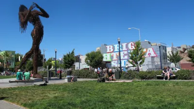
John King examines "when a double-deck roadway is erased from the map," along with the Congress for New Urbanism, which recently brought a group of visitors in from the "eastern half of the United States" to examine the Octavia Boulevard case study, which replaced a portion of the Central Freeway.
"Octavia Boulevard opened in 2005, nearly 16 years after the Loma Prieta earthquake damaged pillars supporting the elevated concrete roadway erected in 1959. The ramps extending across Hayes Street to Gough and Franklin streets, which never reopened, were dismantled in 1992. But the connection that crossed Market Street to Oak and Fell streets remained in place until 2003, with four elections along the way to decide whether it should stay or go."
"Now the freeway touches down at Market Street before shifting to a boulevard with two lanes of traffic on either side of a median filled by thick poplars. On either side, there's an additional lane for local traffic, set apart from the central lanes by elms and shrubs to buffer the adjacent blocks from the commuter slog."
FULL STORY: Road to rebirth? S.F.'s post-freeway Octavia may be a model

More Improvements Coming for Octavia Boulevard in San Francisco
The street that benefitted by one of the most high-profile and successful freeway removals in the country is due for another makeover.
San Francisco Planners Pitch Freeway Removal
Planners in the city of San Francisco have a proposed a $1.4 million study to examine the possibility of removing part of Interstate 280 in the city and convert a rail yard would yield 37 acres of prime urban real estate.
When Removing a Freeway Becomes Mundane
As a growing number of communities study freeway removal, what if the decision was no longer controversial? In Long Beach, California, two city-owned freeways carry less traffic than some neighborhood streets. Would anyone notice if they were gone?

National Parks Layoffs Will Cause Communities to Lose Billions
Thousands of essential park workers were laid off this week, just before the busy spring break season.

Retro-silient?: America’s First “Eco-burb,” The Woodlands Turns 50
A master-planned community north of Houston offers lessons on green infrastructure and resilient design, but falls short of its founder’s lofty affordability and walkability goals.

Delivering for America Plan Will Downgrade Mail Service in at Least 49.5 Percent of Zip Codes
Republican and Democrat lawmakers criticize the plan for its disproportionate negative impact on rural communities.

Test News Post 1
This is a summary

Test News Headline 46
Test for the image on the front page.

Balancing Bombs and Butterflies: How the National Guard Protects a Rare Species
The National Guard at Fort Indiantown Gap uses GIS technology and land management strategies to balance military training with conservation efforts, ensuring the survival of the rare eastern regal fritillary butterfly.
Urban Design for Planners 1: Software Tools
This six-course series explores essential urban design concepts using open source software and equips planners with the tools they need to participate fully in the urban design process.
Planning for Universal Design
Learn the tools for implementing Universal Design in planning regulations.
EMC Planning Group, Inc.
Planetizen
Planetizen
Mpact (formerly Rail~Volution)
Great Falls Development Authority, Inc.
HUDs Office of Policy Development and Research
NYU Wagner Graduate School of Public Service